Exploring Telford
The Old Canal System
This section of the canal is lost except for a short section at the top of the site of Ketley Inclined Plane.
I went looking for it in the wrong place.
The junction for the Ketley arm would have been near Canongate, close to the modern Queensway - at the time of writing, houses are being built there. It may have crossed Lion Street where there is a white gate in a wall at the top, just below the Greyhound. It followed the line of Telford's Holyhead Road, but perhaps a little to the north and therefore at a slightly lower level; and it is clearly shown on the Wrockwardine Parish map. Some slight indications of the possible line may be guessed at from the alignment of buildings and paths visible from Holyhead Road, and there are tantalising clues, but nothing to see, in the names of Pear Tree Bridge Inn and Hartsbridge Road.
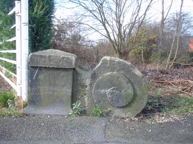
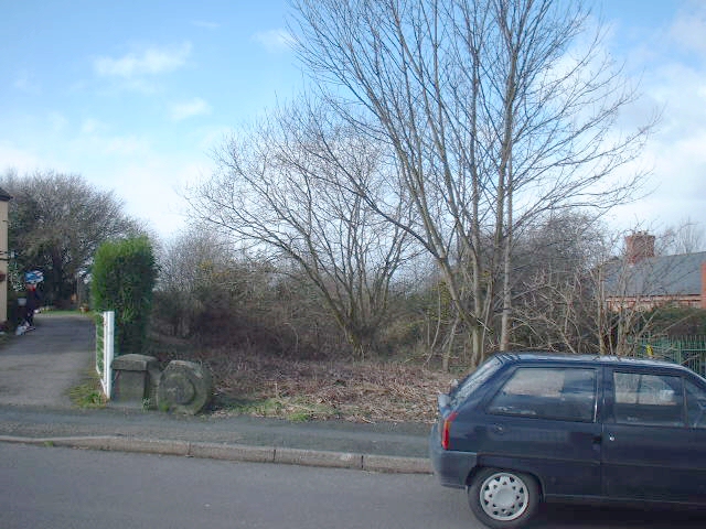
J Westwood told me that If you turn down Hartsbridge Road opposite the Rose and Crown pub going towards Oakengates Hill, just past the white cottage on your left you will see a corner stone belonging to the Hartsbridge canal bridge. It is square and with a carved snail-like pattern attached to it. Funny enough I have seen another one very similar, painted white, by the bend in Church St Hadley, and I have often wondered whether this also came from the Ketley canal; and here is a picture of it. Given that clue, the indentation of the ground and the line of the canal hedge can be seen both to the east and to the west, where the course is actually quite obvious.
Somewhere between Beveley Island on the modern road and the Pudding Inn Telford's road and the old Roman road join, the canal crossed the road. There is an enticing "dead end" in the car park of the furniture store there; and the canal certainly went across the gardens of the houses beyond that point before entering a tunnel under Shepherd's Lane.
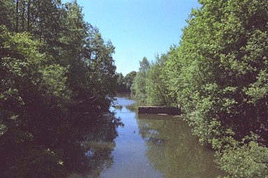
To see the one remaining piece of extant canal on this section, you walk up Shepherd's Lane, taking a footpath through a stile to the right, then doubling back down a set steep slope made into steps by the use of wooden reinforcements. At the bottom, you will cross the end of a short section of canal, in water, and vouched for as genuine by a 1901 OS 25" reprint; whilst the shape of the tunnel entrance is clear enough to your right.
It is possible to make your way along the canal bank through the woods, but the apparent path fizzles out and the going becomes inconvenient (especially in the rain and in the dark - fool that I am!); and it gets you nowhere: the other end is blocked by the gardens of private houses on Red Lees.
From Red Lees there is a path leading on, and a further section of the canal, dry but unmistakable, will be found leading off from the right of the path after fifty yards or so. The end of this section, at the top of a slope, no doubt indicates the top of Ketley Inclined Plane.
The bottom would then have been near the modern parade of shops in Ketley Town, the canal ending in the grounds of Clay Colliery and the industrial estate which has been developed on its site.
The Ketley Inclined Plane was the first to be constructed, by William Reynolds in 1788.