Exploring Telford
The Old Canal System
The canal from Hollinswood and all points south had a junction with the Ketley branch near Canongate in Oakengates. That it crossed Canongate about where Queensway does now, can be deduced from its line further north and from "information received" that it followed the unnamed road past the back of the industrial premises there, crossing Station Road and running along Willows Road. Where Willows Road bends to the east, the canal continued through somebody's living room and on to the side of the Cockshutt behind.
My information is not totally correct, since it stated that the railway bridge, perhaps twenty feet of height lower down on Canongate, was first used by the canal: this cannot be true, from even a casual study of the contours. And examining the contours, I am inclined to the view that the canal actually ran through the grounds of the premises on Station Road and Willows Road, a little lower down, parallel to rather than along the streets as I have described it.
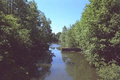
Once on the Cockshutt, the dry bed can be found to the east of the footpath as far as Lincoln Hill, where it has been filled in and garages built upon it.
It must have continued through the back of premises there and on Union Road and Woodlands Villas - the line can be discerned clearly enough from the ends of those roads - but it cannot be walked. There is a very pleasant detour through the woods of the Cockshutt, however.
Another correspondent wrote to me (Jan 2003) that
I live at the bottom of the Cockshutt in Wrockwardine Wood and love to imagine the busy scene that would have taken place there when the canal was working. There was a pub called The Bird in Hand which has now been demolished. The canal seems to have passed close by the pub and there's a nice old piece of curving wall there.
Ten years later (Apr 2013) Rob Hall offered a further correction:
I have read your article on the canal running through the Cockshutt and “Think” I may have spotted a small error... You print a quote from another researcher who states the canal ran the back of where the Bird in hand pub was. I am 100% certain this was the route of the Lillishall Company mineral railway that ran from the new yard under the old tin bridge (Now almost completely gone) through to Willows Road and crossing at Station Hill. The Canal ran from the inclined plane as you mention but then in an almost straight line to where you have picked it up by the Silken Way path. It then curved round and met up with Willows Road. I have recently walked the route and there is a deep cutting still evident through the woodland.
The path through the woods leads back to the rear of the last of these houses; and the canal, still dry, emerges from the side of the garden into the woods. It can be followed from there to a brick wall, no doubt the remains of a bridge, at the top of the Wrockwardine Wood Inclined Plane. You can stand at the top of the incline and look down; you can stand on Summer Crescent and look up it. The bottom was about where Furnace Lane and Plough Road meet and Wrockwardine Wood Way flies over.
I was told by someone who was born there that the incline ended next to "the Methodist chapel". I now realise that the chapel referred to is not the brick chapel adjacent to Wrockwardine Wood Way, but the corrugated-iron one at the end of Smith Crescent!
The map from 1937 that Nigel Witter sent me in March 1999 clearly shows the junction next to the Tin Chapel, north of Smith Crescent and behind the houses in Furnace Lane. The apparent tunnel under Smith Crescent was a bridge, and as Bryan Lea explained, the land beyond has been raised by landfill in the '60s and '70s.