Exploring Telford
The Old Canal System
This section of the canal was part of the last to be in use, bringing goods between the Shrewsbury - Newport canal via Trench to a flour mill at Wrockwardine Wood until some time between the Wars; but it has since been heavily built over in places. The location of the junction here has given me great difficulty, because of changes in the land level through mining and landfill, but thanks to the map sent to me by Nigel Witter (1937) I think what follows is at last correct:
From the junction next to the Tin Chapel at the bottom of the Wrockwardine Wood Inclined Plane, the canal moved east. There was a bit of a southerly kink, but it crossed St Georges Road somewhere between Bradley Road and St Matthews Road, probably at High Mount - the footpath opposite lines up so nicely with the end of Canal Side. It would then have curved round through the houses to cross Donnington Wood Way where there is now a cycle track from the end of Bradley Road and turned left (not going on towards the underpass).
Alistair Young (Jan 2003) described the area as he remembered it:
When I was a child back in the late 50s early 60s there was still a good section of the canal on the cinderhill. It ran under the bridge from Canal Side towards Donnington, across the main road near High Mount and down towards what used to be called Jack Ashley's Pool, then on towards Granville Colliery. There were the remains of some large pumping engine houses (locally called the Black Castle). The bridge on the Cinderhill still has deep grooves cut into its sides, where the ropes used to rub when the tubs were pulled through. There used to be houses around the bridge area, but these were knocked down to make way for Smiths Crescent.
"Brian" sent me this note from the USA:
I spent my childhood in the Donnington/Donnington Wood/Wrockwardine Wood areas of Telford and can remember "the cut" (a nickname my parents deeply disliked) which was behind St Matthews Road. Primarily I remember it for its ash groves from which as a boy I made my bows and arrows - and of course each Sunday morning the miners would be there with jugs of beer playing cards. I think that was the reason for my parents distrust of the cut. Happy memories!
Whilst I now live in the USA and am approaching my sixtieth birthday my childhood memories are strong and that area of Shropshire was a wonderful place to wander and grow up in.
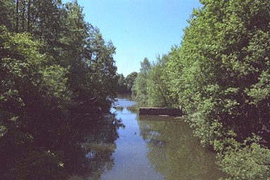
There is a gate and a path into Granville Country Park there - the site of the former Granville Colliery, and others, that the canal served. As the path curves round to the left, there are signs to the left which the eye of faith can believe to be the canal bed. Continuing forwards, beyond a junction of five paths, the curve to the left continues and the signs get more convincing, the path on the modern map matching perfectly the curve of the canal on the old one. Recent (June 1999) work involving heavy vehicles has involved the upgrading of the path to an access road, in the process destroying any last traces there may have been when I first explored here.
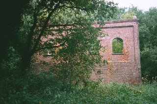
Somewhere here there was a branch to the south, which led to The Lodge furnaces the other side of Granville road. There was a bridge under the road, shown on the local council's Grenville Country Park leaflet, but now destroyed: only some of the brickwork of the buttresses remains on one side. North of the road the land level has been raised so considerably that it is hard to imagine a canal ever ran that way - perhaps a later colliery mound?
The branch terminus ended in a pool which can still be seen from the road, whilst the furnace ramps and remains of the furnaces, and the ruins of some stables and offices, stand nearby. Beyond them is a pool that was a canal reservoir.
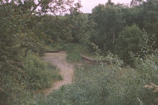
On the main arm, there's a hiccup. The path drops down a bank (ignoring the new wide tracks to left and right) to a wide bridleway which is a former railway. Have faith, climb the path the other side of the cutting, and turn left. This is another railway, now a bridleway, with a rustic fence to separate people and horses (as had the first one, too). Follow it, looking for a steeply sloping path forking right. When you take that path, at the bottom of the bank you are standing in the canal bed. I suppose the railway cut through the canal, and a pit mound grew up in its course. Whatever, it still fits well with the old map.
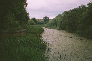
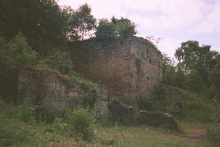
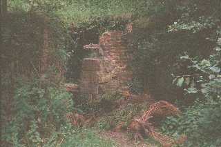
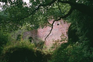
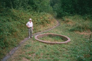
Now you can follow the canal bed all the way to Muxton Bridge - although it's a bit scratchy, and in the autumn, muddy (it was all right the first time, in August). If you follow the upper path instead, it will bring you to almost the same place - Muxton Lane, a hundred yards from its end at The Shropshire Golf Club car park, and in (or on the canal itself, next to) a public car park. To the north, here, lie remains of the engine house Pic 1 Pic 2, beam engine and shafts of Muxton Colliery.
The canal crossed the road and followed the line of a hedge which you can see, in a loop to the right. There is a public footpath through the golf club, so you can walk parallel to the canal along the lane and across the car park; and on the other side, the canal is in water. It leads to the right, and loops round crossing over a stream (much use of which is made by the golf club for water hazards). The canal is dammed part way round the loop, by the start of the Blue Course, but the dry bed continues a little further. At the start of the Silver Course, the path turns right, and the golf pro or groundsman or whoever inhabits the hut there looks to see that you are not tempted to trespass; but you can see over the hedge that that's it for the moment, as the canal peters out on a fairway.
That's also the end of Telford; but the canal went on to Pave Lane, where there was a wharf on the Newport - Wolverhanpton road, with an important branch from Hugh's Bridge to Lilleshall.