Exploring Telford
The Old Canal System
The canal began near Coalport Bridge, where there was a series of short self-acting inclined planes to lower goods from the canal to the river. Originally there had been a lock, but this was unsuccessful owing to the unsuitability of river and canal craft for each other's environments, so it was filled in. The canal tub boats - steel rectangular vessels about sixteen feet by six - were unstable in the swift and choppy waters of the Severn, whilst the Severn trows were considerably too large to navigate the canal.
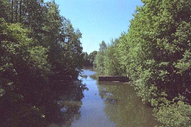
From there it ran for half a mile along the bank to the Coalport China Works, now a museum - a ditch remains for part of the way - and past it to the foot of Hay Inclined Plane, now within the Blists Hill museum. This section has been restored, having been filled in in 1920, and is in water, complete with ducks. It was first restored in 1974-6, and the wooden lining of the restoration replaced with brick in 1974.
The Hay Inclined Plane has also been restored, and is famous; but the rails on it are later railway lines. More detail
The lower path through the museum emerges half way up the incline. It is steep, and those dedicated to walking every inch of the canal will be apt to be out of breath after climbing down to the bottom, then all the way up again! It rises 207ft (63.9m) and is 320ft (292.6m) long.
The stretch through the museum has been restored, and is normally in water, although when I explored it for this review it was dry, very much to my surprise - even though it was during a hot dry spell in summer. There are stop locks along this stretch, which, I read somewhere, date from a time when the bank collapsed - this much have been a wet experience for those living at the bottom of the precipitous drop to the left - so that the rest of the canal could be returned to service whilst repairs were carried out.
At the time of my visit there was a tub boat moored at the wharf next to the steam-driving mine pithead exhibit. It is a very simple design: an iron box about sixteen feet by six.
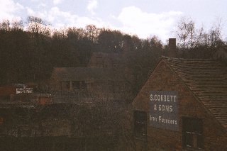
This section of the canal ends at the former Madeleywood Brick and Tile Company's works, beyond which there is a building which straddles the path of the canal. This is in the works yard of the museum, which is closed to the public. The wharves on both sides of the canal were used by the Brick and Tile Company for the delivery of materials and for shipping bricks out.
Outside the museum, the line of the canal can be deduced to have run from the back of the building which straddles it, visible over the fence, under the coach park and overflow car park, to connect with another stretch which leads off through the woods opposite. The path is to the right, and is easy walking and very pleasant. The first part of this is in water, albeit somewhat covered in whatever green stuff it is grows on still waters.
Where the paths divide the canal fizzles out, but it can be deduced from the contour that it continued at a level between the upper and lower paths, crossing the Sutton Hill to Madeley tarmac path. The hedge at the back of houses on Hills Lane Hills Lane is very old and might be one of the hedges which (I am told) lined the canal; thence, probably, across the Play Centre car park, behind the Jehovah's Witness Kingdom Hall, across Queen Street (perhaps following the line of a modern path) and along the back of houses in Bennet Road to Kemberton Road and Prince Street.
Across a wall in Prince Street can be seen a depression in the garden of a house, which I believed to indicate where the canal ran. The footpath to Tweedale would have been the towpath. This was confirmed (May 2000) by Chris Williams, who told me,
You may by now have had confirmation that the canal across Prince St. in Madeley was where the stone bridge is, but I can confirm that you were correct. If you stand looking down Prince St towards the Cuckoo Oak there are two houses that are on the angle where Tweedale Crescent and Prince St meet. The left hand of the two used to belong to my great aunt. At the end of her garden was a gate that led directly onto the (by then defunct) towpath. The canal ran between the gardens and the old garage just down the road on the left.
In the late 50's the canal on this side of the road was still visible but heavily overgrown. On the other side of Prince St it was more difficult to make out.
After passing through Tweedale Industrial Estate (where no trace remains) it crossed Bridgnorth Road about opposite Tweedale North and the Severn Gorge Caravan Park near the Cuckoo Oak pub (there is even a trace on the Tweedale side of the road which, with imagination, one might believe to be a bit of the bank and hedge), running in a straight line to and up the Windmill Farm Inclined Plane. This incline rose 125ft, and was long - 600 yards, or almost a third of a mile, meaning that it occupied the whole distance between the Bridgnorth Road and Windmill Farm. Its course lay between Blakemore and Brereton on the modern Brookside estate. Nothing remains, for the canal was out of use long before Halesfield Colliery, which seems to have used the site for a spoil heap.
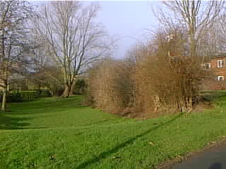
I thought that nothing remained in Brookside. Tony Clayton's map shows the canal meandering past Brookside School, the Windmill Farm incline lying just to its south. However, Sandra Moore, a student of ancient hedgerows in Madeley parish, took me to see a section of hedge and a depression which clearly mark the position of the canal at the top of the incline. We followed the line it indicates, and curing round to the right and left following the contour brought us to Brookside Avenue opposite to the backs of houses on the north side of Lambeth Drive. Across the road, behind the houses, stands a single ancient hawthorn that might have been part of the hedge.
From there, still following the contour, we curved left and right, and reached a short section of ancient hedge at the back of houses on Chapman's Close. Although only a short section of the hedge remains, the boundary it marked is now that of the line of houses, and led us to Aqueduct Lane just opposite a footpath which leads down to Silkin Way. The old roadside hedge has a break here, and beside the path there are some old hawthorn bushes which clearly were once "laid" as part of a hedge (it doesn't show up too well on the photo: look closely in the middle of the picture): this, then, is the location of the canal junction.
This might seem at first a meandering route; but this was an early canal, built along the contours of the land, and in fact the route accords well with the David and Charles map.
The junction would have been some 12 feet above the level of the Silkin Way footpath (See Aqueduct to Hollinswood).